 Back
BackFreshwater Systems & Resources: Structure, Distribution, Human Impact, and Solutions
Study Guide - Smart Notes
 Tailored notes based on your materials, expanded with key definitions, examples, and context.
Freshwater Systems
Global Distribution of Water
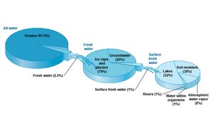
Earth's water is predominantly found in oceans, with only a small fraction available as fresh water. Understanding the distribution of water is crucial for managing resources and addressing scarcity.
Fresh water constitutes only 2.5% of Earth's total water.
Of this, 79% is locked in ice caps and glaciers, 20% is groundwater, and only 1% is surface water.
Surface water is mainly found in lakes, soil moisture, rivers, and atmospheric vapor.
The Water Cycle
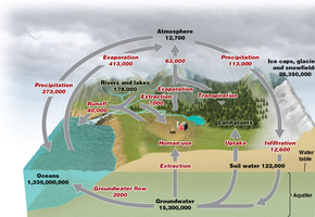
The water cycle describes the continuous movement of water on, above, and below the surface of the Earth. It is essential for replenishing freshwater systems and maintaining ecological balance.
Evaporation and transpiration move water from land and water bodies to the atmosphere.
Precipitation returns water to the surface.
Runoff and infiltration direct water into rivers, lakes, and aquifers.
Human activities, such as extraction and land use, alter the natural flow and distribution of water.
Groundwater
Structure and Types of Aquifers
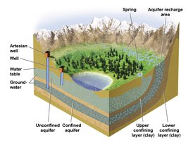
Groundwater is stored beneath the surface in porous materials and is a major source of fresh water for humans and ecosystems.
Aquifers are underground layers of water-bearing rock, gravel, or sand.
Water table is the upper boundary of an aquifer where the soil is saturated with water.
Recharge zone is the area where water infiltrates the surface and replenishes the aquifer.
Confined (artesian) aquifer is trapped between impermeable layers and under pressure.
Unconfined aquifer is not bounded by impermeable layers and is more easily recharged.
Ogallala Aquifer
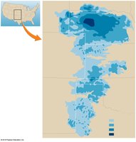
The Ogallala Aquifer is one of the largest aquifers in the world, providing water to several states in the central United States. Its sustainable management is critical due to slow recharge rates and high extraction.
Located beneath parts of Wyoming, South Dakota, Nebraska, Kansas, Colorado, New Mexico, Oklahoma, and Texas.
Varying saturated thickness, with some areas heavily depleted.
Surface Water
Types and Features
Surface water includes rivers, lakes, ponds, and wetlands. These systems are vital for biodiversity, human use, and ecosystem services.
Surface water is found on Earth's surface in rivers, lakes, and ponds.
Runoff is water from precipitation that flows over land.
Tributary is a smaller stream feeding into a larger one.
Watershed is the area drained by a river and its tributaries.
Floodplain is periodically flooded land adjacent to rivers, depositing nutrient-rich silt.
Lakes and Ponds: Zones and Characteristics
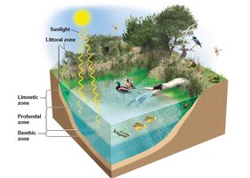
Lakes and ponds are standing surface water bodies with distinct ecological zones and varying nutrient levels.
Littoral zone: shallow area with rooted plants.
Benthic zone: bottom of the water body.
Limnetic zone: open water near the surface.
Profundal zone: deep water not reached by sunlight, low oxygen.
Oligotrophic: low nutrients, high oxygen.
Eutrophic: high nutrients, low oxygen.
Wetlands
Wetlands are areas with saturated soils and specialized vegetation, providing essential ecosystem services.
Freshwater marsh: shallow water, no trees.
Swamp: shallow water, forest vegetation.
Bog: thick floating mats of vegetation.
Vernal pool: seasonal wetlands.
Wetlands slow runoff, filter pollutants, recharge aquifers, reduce flooding, and provide wildlife habitat.
Human Impacts on Freshwater Systems
Overwithdrawal and Distribution
Human activities have significantly altered freshwater systems, leading to overuse, pollution, and changes in distribution.
70% of freshwater use is for agriculture, 20% for industry, and 10% for residential use.
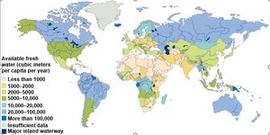
Many regions withdraw water at unsustainable rates, especially for irrigation.
Distribution of water resources does not match population centers, leading to efforts to reroute water.
Groundwater Depletion
Groundwater is depleted when extraction exceeds recharge, causing water tables to drop and leading to issues such as saltwater intrusion and land subsidence.
Groundwater recharge is slow, making depletion a major concern.
1/3 of humans and 99% of US rural dwellers rely on groundwater.
Bottled water production increases energy use and plastic waste.
Overuse of Surface Water
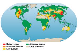
Many regions experience high, moderate, or low overuse of surface water, impacting sustainability and ecosystem health.
15-35% of water withdrawals for irrigation are unsustainable.
Overuse is mapped globally, with some areas facing severe shortages.
Levees, Diversions, and Dams
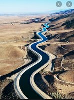
Human structures such as levees, aqueducts, canals, and dams alter natural water flow, impacting habitats and increasing risks.
Levees protect from floods but can disrupt natural floodplain processes.
Aqueducts and canals channel water to desired locations.
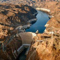
Dams create reservoirs, change stream habitats, and pose risks if breached.
Many older dams are being removed, but new ones are built for water storage.
Solutions to Water Scarcity and Pollution
Desalinization
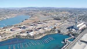
Desalinization is the process of removing salt from seawater to produce fresh water, typically through distillation or reverse osmosis.
Requires significant energy, produces salty waste, and is expensive.
Used mainly in wealthy countries.
Reducing Agricultural Demand
Improving agricultural practices can reduce water demand and increase sustainability.
Level fields to prevent runoff.
Line irrigation canals to reduce leaks.
Use efficient irrigation methods.
Grow crops suited to local conditions.
Breed crops for high yield with low water use.
Lowering Residential Water Use
Residential water conservation involves using efficient fixtures, reusing water, and landscaping with drought-resistant plants.
Install water-saving faucets, showers, and toilets.
Reuse rainwater and gray water.
Use xeriscaping instead of watering lawns.
Recycle water and reduce leaks.

Pollution Control
Water pollution is a major issue, with point-source and non-point source pollution requiring different management strategies.
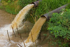
Point-source pollution: identifiable entry point (e.g., pipes).
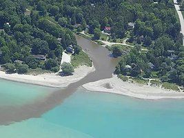
Non-point source pollution: diffuse sources (e.g., runoff).
Legislation, such as the Clean Water Act, targets point-source pollution.
Types of Water Pollution
Chemicals, Pathogens, and Nutrients
Water pollution includes a variety of contaminants that impact ecosystems and human health.
Chemicals: pesticides, petroleum products, mine drainage, acid rain.
Pathogens: disease-causing organisms.
Excess nutrients: cause eutrophication and hypoxia.
Wastewater: includes gray water and sewage; treatment is essential.
Sediment erosion and thermal pollution from industry or dams.
Groundwater Pollution
Groundwater pollution is particularly problematic due to the difficulty of remediation. Pollutants can seep into aquifers from various sources.
Sources include agriculture, industry, leaking tanks, urban sites, and nuclear waste facilities.
Reducing Water Pollution
Legislation and treatment methods are used to reduce water pollution and protect public health.
Clean Water Act (1977): regulates point-source pollution, sets standards, funds treatment plants.
Drinking water is treated and regulated.
Wastewater treatment includes primary and secondary processes.
Artificial wetlands can be used for secondary treatment.
Hydraulic Fracking
Process and Environmental Impact
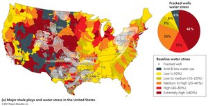
Hydraulic fracking is a method for extracting oil and gas from shale, involving high-pressure water, sand, and chemicals. It poses risks to water resources, especially in water-scarce areas.
Drilling deep and horizontally to reach shale.
Explosions fracture the shale, sand keeps fractures open, and oil/gas are extracted.
Requires large amounts of water and may pollute water sources.
Summary Table: Types of Water Pollution
Type | Source | Impact |
|---|---|---|
Chemicals | Agriculture, industry, mining | Toxicity, ecosystem disruption |
Pathogens | Sewage, animal waste | Disease, health risk |
Excess nutrients | Fertilizers, wastewater | Eutrophication, hypoxia |
Sediment | Erosion, construction | Habitat loss, water quality |
Thermal | Industry, dams | Temperature changes, stress on organisms |
Key Equations
Water Balance Equation
The water balance equation is used to quantify the movement and storage of water in a system:
Conclusion
Freshwater systems are vital for life and human society. Understanding their structure, distribution, and the impacts of human activity is essential for sustainable management and conservation. Solutions include technological advances, improved agricultural and residential practices, pollution control, and legislative action.
